
Captain James Cook, Navigator
Cartography
Captain Cook
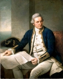
He surveyed the lower part of the Saint Lawrence river which led to the siege and capture of Quebec.
In those days, accurate maps and charts were considered highly secret as a weapon of war. Today, Admiralty charts cover the whole world.
Principles of cartography
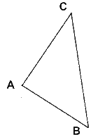
- Point A is a known place, from which you want to start mapping.
- Going in a known direction for a measured distance to point B.
- Measure the direction of point C from both points A and B.
You go to place C and start all over again. With accurate instruments and extreme care, this method can produce results which are still accurate by modern standards.
Finally
The reason for telling you all this is that cartographers needed Tables. Remember Log Tables from your youth? In the eighteenth century, tables were produced by computers.